| |
gison3dmap >> Examples >> Batalha County Community Museum |
<< back |
|
| |
|
|
| |
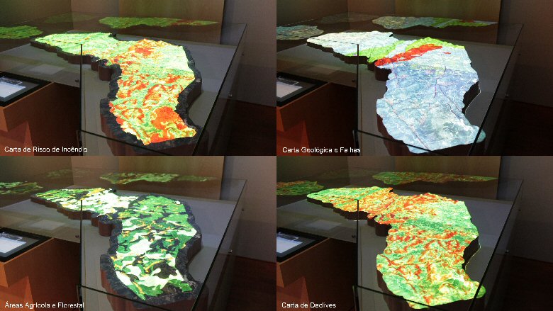
The Batalha County Community Museum is a high quality exhibition space about the history of the Batalha county territory, since the pre-historical times up to the construction of the Batalha Monastery in the XV century, including the Roman presence, in which a virtual recreation of the Collippo town can be seen.
In the "All about us" area of the exhibition, regardind the present times, an interactive 3D solid terrain model of the Batalha county is used, which allows visitors to discover on their own, the natural, cultural, religious and gastronomic routes of the Batalha county.
The particularity of this system resides on the fact that it is the first gison3dmap installation made as part of a museum. The next image gives an idea of the quality and contents diversity of the Batalha County Community Museum, where it can be seen the Batalha county interactive solid terrain model with the county area being projected. |
|
| |
 |
|
| |
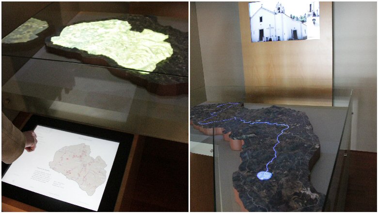
The Batalha county 3d solid terrain model, built with a 1:10.000 scale, has a irregular shape that follows the county limit at a 400 meter distance (4 cm at map scale), and is made of three independent panels.
The Batalha County Community Museum gison3dmap system, uses three XGA Sanyo PLC-XU105 video projectors with 4500 Ansi lumens to project geographical information on top of the 3d solid terrain map, and a 50" LCD screen to show images and videos, synchronized with those projections.
Users interact with the system using a touch screen and a multimedia application that runs on a quiosk integrated with the solid terrain model base table. Contents are focused on the presentation of the various routes of the religious, architectural, natural and gastronomic county heritage.
|
|
| |
|
|
| |
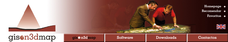
The use of the system is not limited to the contents included within the multimedia application which runs on the quiosk. Two other uses are expected to take place, using GIS clients.
One relates to the possibility to spread the use of the system among the county schools, using a gison3dmap GIS client, based on the VisualSIG freeware GIS software. The other one consists on the use by the county technicians, of ArcGIS running on portable laptops, to present and discuss municipal plans.
The image next shows a collage of 4 images with different geographical information themes of the Batalha county being projected on the 3d map from the ArcGIS client, using a wireless connection with the gison3dmap system (from top to bottom and left to right: fire risk index, geology and faults, forestry and agricultural areas and slope classes). |
|
| |
|
|
| |
^ top |
|
|